ಭಾನುವಾರ, ಆಗಸ್ಟ್ 1, 2021

the Countries with there Capitals, Currencies, Language, & Religion/s −

The following tables illustrates the Countries with tiher Capitals, Currencies, Language, & Religion/s −

CountryCapitalsCurrencyLanguageReligion*
AfghanistanKabulAfghaniPashto, Dari (Persian)Islam
AlbaniaTiranaLekAlbanianIslam, Christianity
AlgeriaAlgiersAlgerian DinarArabic; Tamazight; FrenchIslam
AndorraAndorra la VellaEuroCatalanChristianity
AngolaLuandaKwanzaPortugueseChristianity
Antigua & BarbudaSaint John'sEast Caribbean DollarEnglishChristianity
ArgentinaBuenos AiresArgentine PesoSpanishChristianity (But Secular Country)
ArmeniaYerevanDramArmenianChristianity
AustraliaCanberraAustralian DollarEnglishChristianity (But Secular Country)
AustriaViennaEuroGermanChristianity
AzerbaijanBakuManatAzerbaijaniIslam
The BahamasNassauBahamian DollarEnglishChristianity
BahrainManamaBahraini DinarArabicIslam
BangladeshDhakaTakaBanglaIslam
BarbadosBridgetownBarbadian DollarEnglishChristianity
BelarusMinskBelarusian RubleBelarusian; RussianChristianity
BelgiumBrusselsEuroDutch; French; GermanSecular
BelizeBelmopanBelize DollarEnglishChristianity
BeninPorto-NovoWest African CFA FrancFrenchChristianity
BhutanThimphuNgultrumDzongkhaBuddhism, Hindu
Bosnia & HerzegovinaSarajevoConvertible MarkBosnian; Croatian; SerbianIslam, Christianity
BotswanaGaboronePulaEnglish; TswanaChristianity
BrazilBrasiliaRealPortugueseChristianity
BruneiBandar Seri BegawanBrunei DollarMalayIslam
BulgariaSofiaLevBulgarianSecular
Burkina FasoOuagadougouWest African CFA FrancFrenchIslam, Christianity
BurundiBujumburaBurundi FrancKirundi; FrenchChristianity
CambodiaPhnom PenhRielKhmerBuddhism
CameroonYaoundéCentral African CFA FrancFrench; EnglishChristianity
CanadaOttawaCanadian DollarEnglish; FrenchChristianity (But Secular Country)
Cape VerdePraiaCape Verdean EscudoPortugueseChristianity
Central African RepublicBanguiCentral African CFA FrancSango; FrenchChristianity
ChadN'DjamenaCentral African CFA FrancFrench; ArabicIslam, Christianity
ChileSantiagoChilean PesoSpanishChristianity
ChinaBeijingChinese YuanMandarinN/A
ColombiaBogotaColombian PesoSpanishChristianity
ComorosMoroniComorian FrancComorian; Arabic; FrenchIslam
Democratic Republic of the CongoKinshasaCongolese FrancFrenchChristianity
Republic of the CongoBrazzavilleCentral African CFA FrancFrenchN/A
Costa RicaSan JoseColonSpanishChristianity
Cote d'Ivoire (Ivory Coast)Yamoussoukro; AbidjanWest African CFA FrancFrenchIslam, Christianity
CroatiaZagrebCroatianKunaChristianity
CubaHavanaCuban PesoSpanishChristianity
CyprusNicosiaEuroGreek; TurkishChristianity, Islam
Czech RepublicPragueCzech KorunaCzech; SlovakN/A
DenmarkCopenhagenDanish KroneDanishChristianity
DjiboutiDjibouti CityDjiboutian FrancArabic; FrenchIslam, Christianity
DominicaRoseauEast Caribbean DollarEnglish; French; Antillean CreoleChristianity
Dominican RepublicSanto DomingoDominican PesoSpanishChristianity
East Timor (Timor-Leste)DiliUnited States DollarTetum; PortugueseChristianity
EcuadorQuitoUnited States DollarSpanishChristianity
EgyptCairoEgyptian PoundArabicIslam
El SalvadorSan SalvadorUnited States DollarSpanishChristianity
Equatorial GuineaMalaboCentral African CFA FrancSpanish; French; PortugueseChristianity
EritreaAsmaraNakfaArabic; Tigrinya; EnglishChristianity, Islam
EstoniaTallinnEstonian Kroon; EuroEstonianSecular
EthiopiaAddis AbabaBirrAmharicIslam, Christianity
FijiSuvaFijian DollarEnglish; Bau Fijian; HindiChristianity, Hindu, Islam
FinlandHelsinkiEuroFinnish; SwedishChristianity
FranceParisEuro; CFP FrancFrenchSecular
GabonLibrevilleCentral African CFA FrancFrenchChristianity
The GambiaBanjulDalasiEnglishIslam
GeorgiaTbilisiLariGeorgianChristianity
GermanyBerlinEuroGermanChristianity
GhanaAccraGhanaian CediEnglishChristianity, Islam
GreeceAthensEuroGreek(Christianity) Orthodoxy
GrenadaSt. George'sEast Caribbean DollarEnglish; PatoisChristianity
GuatemalaGuatemala CityQuetzalSpanishChristianity
GuineaConakryGuinean FrancFrenchIslam, Christianity
Guinea-BissauBissauWest African CFA FrancPortugueseIslam, Christianity
GuyanaGeorgetownGuyanese DollarEnglishChristianity, Hindu, Islam
HaitiPort-au-PrinceGourdeHaitian Creole; FrenchChristianity
HondurasTegucigalpaLempiraSpanishChristianity
HungaryBudapestForintHungarianChristianity
IcelandReykjavikIcelandic KronaIcelandicChristianity
IndiaNew DelhiIndian RupeeHindi; EnglishSecular
IndonesiaJakartaRupiahIndonesianIslam
IranTehranRialPersianIslam
IraqBaghdadIraqi DinarArabic; KurdishIslam
Republic of IrelandDublinEuroEnglish; IrishChristianity
IsraelJerusalemShekelHebrew; ArabicJudaism, Christianity, Islam, Druze
ItalyRomeEuroItalianChristianity
JamaicaKingstonJamaican DollarEnglishChristianity
JapanTokyoYenJapaneseBuddhism or Shinto (But Secular Country)
JordanAmmanJordanian DinarArabicIslam
KazakhstanAstanaTengeKazakh; RussianIslam, Christianity
KenyaNairobiKenyan ShillingSwahili; EnglishChristianity
KiribatiTarawa AtollKiribati DollarEnglish; GilberteseChristianity
North KoreaPyongyangNorth Korean WonKoreanSecular
South KoreaSeoulSouth Korean WonKoreanAtheist (but some follow Buddhist & Christian)
KosovoPristinaEuroAlbanian; SerbianIslam
KuwaitKuwait CityKuwaiti DollarArabic; EnglishIslam
KyrgyzstanBishkekSomKyrgyz; RussianIslam, Russian Orthodoxy
LaosVientianeKipLao (Laotian)Buddhism
LatviaRigaLatsLatvianChristianity
LebanonBeirutLebanese PoundArabic; FrenchIslam, Christianity
LesothoMaseruLotiSesotho; EnglishChristianity
LiberiaMonroviaLiberian DollarEnglishChristianity
LibyaTripoliLibyan DinarArabicIslam
LiechtensteinVaduzSwiss FrancGermanChristianity
LithuaniaVilniusLithuanian LitasLithuanianChristianity
LuxembourgLuxembourgEuroGerman; French; LuxembourgishChristianity (But it is a Secular Country)
MacedoniaSkopjeMacedonian DenarMacedonianChristianity, Islam
MadagascarAntananarivoMalagasy AriaryMalagasy; French; EnglishTraditional Religion
MalawiLilongweMalawi KwachaEnglishChristianity, Islam
MalaysiaKuala LumpurRinggitMalayIslam
MaliBamakoWest African CFA FrancFrenchIslam, Christianity
MaltaVallettaEuroMaltese; EnglishChristianity
Marshall IslandsMajuroUnited States DollarMarshallese; EnglishChristianity
MauritaniaNouakchottOuguiyaArabicIslam
MauritiusPort LouisMauritian RupeeEnglishChristianity, Islam
MexicoMexico CityMexican PesoSpanishChristianity
Federal States of MicronesiaPalikirUnited States DollarEnglishChristianity
MoldovaChisinauMoldovan LeuMoldovan (Romanian)Christianity
MonacoMonacoEuroFrench; Italian; EnglishChristianity
MongoliaUlaanbaatarTogrogMongolianBuddhism
MontenegroPodgoricaEuroMontenegrinIslam, Christianity
MoroccoRabatMoroccan DirhamArabicIslam
MozambiqueMaputoMozambican MeticalPortugueseChristianity, Islam
Myanmar (Burma)NypyidawKyatBurmeseBuddhism
NamibiaWindhoekNamibian DollarEnglish; Afrikaans; GermanChristianity
NauruYarenAustralian DollarEnglish; NauranChristianity
NepalKathmanduNepalese RupeeNepaliHindu, Buddhism, Islam
NetherlandsAmsterdam; The HagueEuroDutchChristianity (But a Secular Country)
New ZealandWellingtonNew Zealand DollarEnglishChristianity (But a Secular Country)
NicaraguaManaguaCordobaSpanishChristianity
NigerNiameyWest African CFA FrancFrenchIslam, Christianity
NigeriaAbujaNairaEnglishChristianity, Islam
NorwayOsloNorwegian KroneNorwegianChristianity
OmanMuscatOmani RialArabicIslam
PakistanIslamabadPakistani RupeeUrdu; EnglishIslam
PalauMelekeokUnited States DollarEnglish; PalauanChristianity
PanamaPanama CityBalboaSpanishChristianity
Papa New GuineaPort MoresbyPapa New Guinean KinaEnglish; Tok Pisin; Hiri MotuChristianity
ParaguayAsuncionGuaraniSpanish; GuaraniChristianity
PeruLimaNuevo SolSpanishChristianity
PhilippinesManilaPhilippine PesoFilipino; EnglishChristianity, Islam
PolandWarsawZłotyPolishChristianity
PortugalLisbonEuroPortugueseChristianity
QatarDohaQatari RiyalArabicIslam
RomaniaBucharestRomanian RupeeRomanianChristianity
RussiaMoscowRubleRussianChristianity
RwandaKigaliRwandan FrancKinyarwanda; French; EnglishChristianity
Saint Kitts and NevisBasseterreEast Caribbean DollarEnglishChristianity
Saint LuciaCastriesEast Caribbean DollarEnglish; FrenchChristianity
Saint Vincent & The GrenadinesKingstownEast Caribbean DollarEnglishChristianity
SamoaApiaTalaSamoan; EnglishChristianity
San MarinoSan MarinoEuroItalianChristianity
Sao Tome and PrincipeSao TomeDobraPortugueseChristianity
Saudi ArabiaRiyadhSaudi RiyalArabicIslam
SenegalDakarWest African CFA FrancFrenchIslam
SerbiaBelgradeSerbian DinarSerbianChristianity
SeychellesVictoriaSeychoellois RupeeSeychellois Creole; French; EnglishChristianity
Sierra LeoneFreetownLeoneKrio; EnglishIslam, Christianity
SingaporeSingaporeSingapore DollarEnglish; Malay; Mandarin ChineseBuddhist, Christianity
SlovakiaBratislavaEuroSlovakChristianity
SloveniaLjubljanaEuroSloveneChristianity
Solomon IslandsHoniaraSolomon Islands DollarSolomons PijinChristianity
SomaliaMogadishuSomali ShillingSomali; ArabicIslam
South AfricaPretoria; Cape Town; BloemfonteinRandZulu; Xhosa; AfrikaansChristianity
SpainMadridEuroSpanishChristianity
Sri LankaColomboSri Lankan RupeeSinhala; TamilBuddhist, Hindu, Islam
SudanKhartoumSudanese PoundArabic; EnglishIslam
SurinameParamariboSurinamese DollarDutchChristianity
SwazilandMbabaneLilangeniEnglish; SiSwatiChristianity
SwedenStockholmSwedish KronaSwedishChristianity
SwitzerlandBerneSwiss FrancGerman; French; ItalianChristianity
SyriaDamascusSyrian PoundArabicIslam, Christianity
TaiwanTaipeiNew Taiwan DollarMandarinPolytheistic ancient Chinese religion, Buddhism
TajikistanDushanbeSomoniTajik; RussianIslam
TanzaniaDar es Salaam; DodomaTanzanian SchillingSwahiliIslam, Christianity
ThailandBangkokThai BahtThaiBuddhism
TogoLomeWest African CFA FrancFrenchTraditional/Native religion, Christianity
TongaNuku'alofaPa'angaTongan; EnglishChristianity
Trinidad and TobagoPort-of-SpainTrinidad and Tobago DollarEnglishChristianity, Hindu, Islam
TunisiaTunisTunisian DinarTunisian; FrenchIslam
TurkeyAnkaraTurkish LiraTurkishIslam (But Secular country)
TurkmenistanAshgabatTurkmen New ManatTurkmen; RussianIslam
TuvaluVaiakuTuvaluan DollarTuvaluan; EnglishChristianity
UgandaKampalaUgandan ShillingSwahili; EnglishChristianity
UkraineKievHryvniaUkrainian; RussianEastern Orthodoxy
United Arab EmiratesAbu DhabiDirhamArabicIslam
United KingdomLondonPound SterlingEnglishChristianity
United States of AmericaWashington D.C.United States DollarEnglish; SpanishChristianity
UruguayMontevideoUruguayan PesoSpanishChristianity
UzbekistanTashkentUzbekistan SomUzbek; RussianIslam
VanuatuPort-VilaVanuatu VatuBislama; English; FrenchChristianity
Vatican CityVatican CityEuroLatin; ItalianChristianity
VenezuelaCaracasBolivar FuerteSpanishChristianity
VietnamHanoiDongVietnameseNative religious practice, Christianity
YemenSanaaYemeni RialArabicIslam
ZambiaLusakaZambian KwachaEnglishChristianity
ZimbabweHarareUnited States DollarEnglishChristianity

*List of religion/s illustrates only those religions, which are practiced by majority of the people (in their respective country). In addition, there are number of religions practiced by minority of people in most of the countries, not enlisted here.

the landlocked countries of the world −

The following table enlists the landlocked countries of the world −

NameContinent/Location
LesothoAfrica (Locked by only one country i.e. South Africa)
Vatican CityEurope (Locked by only one Country i.e. Italy)
San MarinoEurope (Locked by only one Country i.e. Italy)
MongoliaAsia (Locked by two countries namely Russia & China)
BhutanAsia (Locked by two countries namely India & China)
NepalAsia (Locked by two countries namely India & China)
AndorraEurope (Locked by two countries namely France & Spain)
LiechtensteinEurope (it is one of the double landlocked countries between Switzerland & Austria)
MoldovaEurope (Locked by two countries namely Ukraine & Romania)
SwazilandAfrica (Locked by two countries namely South Africa & Mozambique)
UzbekistanAsia (it is double landlocked country surrounded by Afghanistan, Kazakhstan, Kyrgyzstan, Tajikistan, and Turkmenistan
AfghanistanAsia
ArmeniaAsia
AzerbaijanAsia
KazakhstanAsia
KyrgyzstanAsia
TajikistanAsia
TurkmenistanAsia
UzbekistanAsia
LaosAsia
AustriaEurope
BelarusEurope
HungaryEurope
KosovoEurope
LuxembourgEurope
MacedoniaEurope
MoldovaEurope
SerbiaEurope
SlovakiaEurope
SwitzerlandEurope
BoliviaSouth America
ParaguaySouth America
BotswanaAfrica
Burkina FasoAfrica
BurundiAfrica
Central African RepublicAfrica
ChadAfrica
Czech RepublicAfrica
EthiopiaAfrica
MalawiAfrica
MaliAfrica
NigerAfrica
RwandaAfrica
South SudanAfrica
UgandaAfrica
ZambiaAfrica
ZimbabweAfrica

the landlocked states of India −

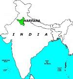
The following table enlists the landlocked states of India −

NameLocationImage
Haryana(North)Haryana
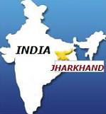
JharkhandEastJharkhand
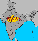
Madhya PradeshCentralMadhya Pradesh
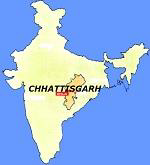
Chhattisgarh(Central) EastChhattisgarh
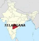
TelanganaSouthTelangana

the important International Boundaries/Lines −

  • The following tables describes the important International Boundaries/Lines −

    S.NoName & Description
    1

    The 17th Parallel

    It is the Line Between North & South Vietnam

    2

    The 38th parallel

    It is the Line Between North & South Korea (Before the Korean war)

    3

    The 49th Parallel (also The Medicine Line)

    It is the Boundary Between Canada & the USA

    4

    The 24th Parallel

    It is the Line that Pakistan claims for the demarcation purpose, but India does not accept it

    5

    The Siegfried Line

    It is the Boundary Between France and Germany

    6

    The Maginot Line

    It is France’s Defensive Line

    7

    The Hindenburg Line

    It was the Line that described Germany’s position during the World War I

    8

    The Oder–Neisse line

    It is the Boundary Between Germany & Poland

    9

    The Radcliffe Line

    It is the Boundary Between India & Pakistan

    10

    The McMahon Line

    It is the Boundary Between India & China (However, originally signed between Britain & Tibet)

    11

    The Mannerheim Line

    It was a defensive line drawn on the Karelian Isthmus by Finland against the Soviet Union

    12

    The Durand Line

    It is the Boundary Between Pakistan & India (formerly between British India and Afghanistan)

    13

    The Line of Control (LoC)

    It is the military control line between India and Pakistan (in the state of Jammu & Kashmir)

    14

    The Line of Actual Control (LAC)

    It is the Effective Boundary between India and China

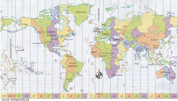
The time line

  • Parallels of longitude determine the time of a given place.

  • Local time (of any place) is measured in reference to Greenwich Time (London), which changes at the rate of four min/degree of longitude.

  • Greenwich Time Line is also known as “Prime Meridian” i.e. 00.

  • International Standard Time is measured in reference of the Prime Meridian (or Greenwich).

  • The Earth rotates through 3600 in 24 hours or 150 in 1 hour or 10 in 4 minutes. Therefore, the local time varies at the rate of 4 min/degree of longitude from the Greenwich Time.

Time Line
  • As shown in the map given above, Kolkata is approximately 900 east of Greenwich; so, Kolkata is (900 x 4 = 360 min) six hours ahead of the Greenwich Time (London).

the major Waterfalls (Based on Height) of the world −

The following table enlists the major Waterfalls (Based on Height) of the world −

WaterfallsHeight (in Meters)LocationOn (River)
Angel Falls979VenezuelaChurun River (a tributary of Orinoco River)
Tugela Falls948South AfricaTugela River
Tres Hermanas Falls914PeruN/A
Olo'upena Falls900Hawaii (USA)N/A
Yumbilla Falls896PeruN/A

The following table enlists the major Waterfalls (Based on Flow Rate) of the world −

WaterfallsMean annual flow rate (m3/s)Width (m)RiverLocation
Boyoma Falls17,0001,372LualabaDemocratic Republic of the Congo
Guaíra Falls13,300ParanaParaguay & Brazil
Khone Phapheng Falls11,61010,783MekongLaos
Niagara Falls2,4071,203NiagaraCanada
Iguazú Falls1,7462,700IguazuArgentina & Brazil
Victoria1,0881,708ZambeziZambia & Zimbabwe

The major Rivers of the world −

The following table enlists the major Rivers of the world −

RiverLength (in KM)Ending PointLocation
Nile6,650Mediterranean SeaAfrica
Amazon6,400Atlantic OceanSouth America
Yangtze6,300East China SeaChina (Asia)
Mississippi–Missouri6,275Gulf of MexicoUSA
Yenisei–Angara– Selenge5,539Kara SeaRussia
Yellow River (Huang He)5,464Bohai SeaChina (Asia)
Ob–Irtysh5,410Gulf of ObAsia
Paraná – Río de la Plata4,880Atlantic OceanSouth America
Congo–Chambeshi (Zaïre)4,700Atlantic OceanAfrica
Amur–Argun4,444Sea of OkhotskAsia

The major Straits* of the world −

The following table enlists the major Straits* of the world −

StraitConnectsSeparates
Bab-el-MandebRed Sea to Gulf of AdenYamen (Asia) from Djibouti & Eritrea (Africa)
Bass straitPacific Ocean (No other water body)Tasmania from the Australian mainland
Bering StraitBering Sea (Pacific Ocean) to Chukchi Sea (Arctic Ocean)Russia from Alaska (USA)
Bosphorus StraitBlack Sea to Sea of MarmaraAsian Turkey from European Turkey
Cook StraitPacific Ocean (No other water body)North Island from South Islands of New Zealand
Davis straitBaffin Bay to Atlantic OceanGreenland from Nunavut (Canada's Baffin Island)
Denmark straitAtlantic Ocean (No other water body)Iceland from Greenland
Dover straitEnglish Channel & North SeaEngland from France
English ChannelNorth Sea & Atlantic OceanEngland from France
Florida StraitGulf of Mexico to Atlantic OceanFlorida (USA) from Cuba
Gibraltar StraitAtlantic Ocean to Mediterranean SeaSpain (Europe) from Morocco (Africa)
Hormuz straitGulf of Oman to Persian GulfUAE & Oman from Iran
Hudson straitAtlantic Ocean to Hudson BayBaffin Island from Quebec (in Canada)
Magellan straitPacific Ocean to Atlantic OceanMainland South America from north and Tierra del Fuego to the south (South America)
Malacca StraitSouth China Sea to Andaman SeaMalay Peninsula from Indonesian island
Mozambique StraitIndian Ocean (No other water body)Madagascar from Mozambique
Palk StraitBay of Bengal to Gulf of MannarIndia from Sri Lanka
Sunda StraitIndian Ocean to Java SeaIslands of Java from Sumatra (Indonesia)
Torres StraitArafura Sea to Coral Sea (Pacific Ocean)Australia from Papua New Guinea
Tsugaru StraitSea of Japan (East Sea) to Pacific OceanHonshu from Hokkaido (Japan)
Yucatan StraitGulf of Mexico to Caribbean SeaMexico from Cuba
100 ChannelBay of Bengal to Andaman SeaIsland of Little Andaman from Car Nicobar Island (of India)
90 ChannelIndian Ocean (No other water body)Laccadive Islands of Kalpeni from Suheli Par, and Maliku Atoll (of India)

*Strait is a thin waterbody that connects two big water masses and separates two land masses.

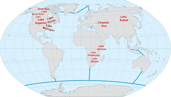
The major Lakes of the world −

The following table enlists the major Lakes of the world −

SeaArea (sq. km)Location (in)
Caspian Sea436,000Asia
Lake Superior82,100North America
Lake Victoria68,870Africa
Lake Huron59,600North America
Lake Michigan58,000North America
Lake Tanganyika32,600Africa
Lake Baikal31,500Russia
Great Bear Lake31,000Canada
Malawi29,500Africa
Great Slave Lake27,00027,000
Major Lakes

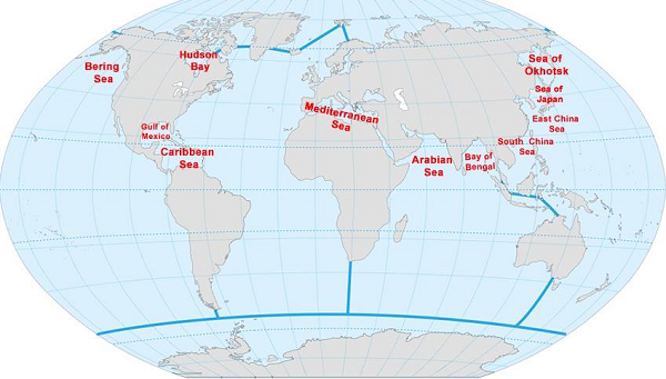
The major Seas of the world −

  • The following table enlists major Seas of the world −

    SeaArea (sq. km)Location (in)
    Arabian Sea3,862,000Indian Ocean
    South China Sea3,500,000Pacific Ocean
    Caribbean Sea2,754,000Atlantic Ocean
    Mediterranean Sea2,500,000Atlantic Ocean
    Bay of Bengal2,172,000Indian Ocean
    Bering Sea2,000,000Pacific Ocean
    Sea of Okhotsk1,583,000Pacific Ocean
    Gulf of Mexico1,550,000Atlantic Ocean
    East China Sea1,249,000Pacific Ocean
    Hudson Bay1,230,000Atlantic Ocean
    Sea of Japan977,980Pacific Ocean

    Major Seas


Hydrosphere system

  • Hydrosphere is the combined name (for the study purpose) given to all the water bodies found on the Earth’s surface, for example, Oceans, Rivers, Lakes, etc.

  • About 71% of the Earth’s surface is covered by water and rest is covered by landmass.

  • About 97.5% (of total hydrosphere) is saline water and rest 2.5% is fresh water.

  • About 68.7% of the fresh water is available in the form of permanent snow found in the regions of Arctic, Antarctic, and other mountain glaciers.

  • About 29.9% fresh water is available in the form of (fresh) groundwater.

  • Only about 0.26% fresh water is easily accessible for the use, available in the form of rivers, lakes, reservoirs, etc.

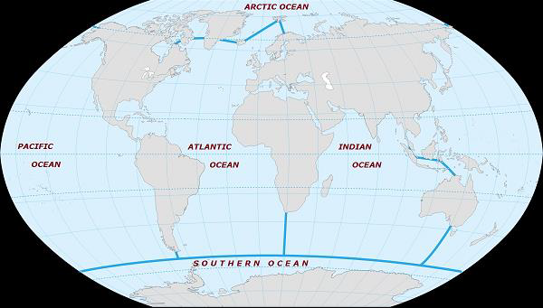
Oceans

  • There are five Oceans namely −

  • Pacific Ocean

  • Atlantic Ocean

  • Indian Ocean

  • Arctic Ocean &

  • Southern Ocean

Southern Ocean
  • The following table describes the major facts of all the five Oceans −

OceanArea (sq. km)% of TotalAvg. Depth (in meter)Deepest Point
Pacific Ocean168,723,00046.63,970Mariana Trench (10,994 m deep)
Atlantic Ocean85,133,00023.53,646Puerto Rico Trench (8,648 m)
Indian Ocean70,560,00019.53,741Diamantina Trench (8,047 m) Sunda Trench (7,725 m)
Arctic Ocean15,558,00015,558,0001,205Eurasian Basin (5,450 m)
Southern Ocean21,960,0006.13,270South Sandwich Trench (7,236 m)

The mountain system

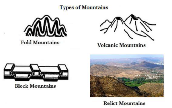
  • Mountain is a large natural elevation of the earth's surface that rises abruptly from the surrounding area.

Types of Mountains

  • The following are the major types of the Mountains −

    • Fold Mountains − e.g. Himalayas (in Asia), Rockies (in North America), Andes (in South America), Alps (Europe), etc.

    • Block Mountains − e.g. Black Forest (Germany), Vosges (France), etc.

    • Volcanic Mountains − e.g. Mt. Vesuvius (Italy), Mt. Fujiyama (Japan), Mt. Cotopaxi & Mt. Chimborazo (South America), etc.

    • Residual/Relict Mountain − e.g. Aravalli, Western Ghats (India), etc.

Types of Mountain

Earth's Rock System

  • Rock is the solid mineral material that forms part of the surface of the earth, exposed on the Earth’s surface or underlying the soil.

  • Rock is divided into following three types −

    • Igneous Rocks

    • Sedimentary Rock

    • Metamorphic Rock

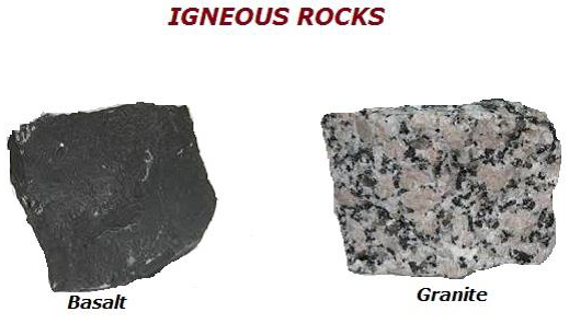
Igneous Rock

  • Igneous Rock is normally formed by the solidification of the molten magma.

  • All other types of rocks are formed by the igneous rock; therefore, igneous rock is also known as primary rock.

  • About 95% of the Earth’s crust is made of igneous rock.

  • Granite, Basalt, and Volcanic rock are the major types of igneous rock.

Igneous Rocks

Sedimentary Rock

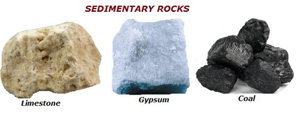
  • The rocks, which is formed because of the deposition of weathered remains of igneous rocks, is known as ‘Sedimentary Rock.’

  • Sedimentary rocks share 5% of the Earth’s surface, but cover (in terms of area) about 75% of Earth’s (exposed) surface.

  • Sedimentary rocks also contain organic materials (i.e. source of energy for the human beings).

  • Major examples of sedimentary rocks are Gypsum, Limestone, Chalk, Coal, Conglomerates, Sandstone, Claystone, etc.

Sedimentary Rocks

Metamorphic Rock

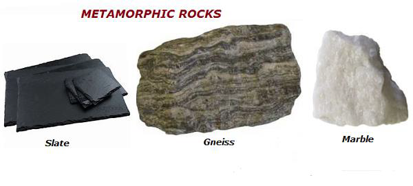
  • Because of the intense pressure, high fluctuating temperature, and presence and absence of moisture and chemicals, over a period of time, igneous rock or sedimentary rocks get modified (metamorphosed) and called as ‘Metamorphic Rock.’

  • Major examples of metamorphic rock are Slate, Gneiss, Marble, Quartzite, etc.

Metamorphic Rocks


Facts of content(ಖಂಡಗಳು)

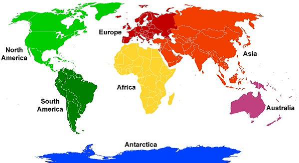
There are seven continents as shown in the image given below −

Seven Continent

The following table illustrates some basic facts of all the continents −

ContinentArea (km2)% of Total Land MassPopulation% of Total Populat ionDensity Per Sq. km
Asia43,820,00029.54,164,252,0006095
Africa30,370,00020.41,022,234,0001533.7
North America24,490,00016.5542,056,000822.1
South America17,840,00012392,555,000622
Europe10,180,0006.8738,199,0001172.5
Australia9,008,5005.929,127,0000.43.2
Antarctica13,720,0009.24,490 (not native population at all)00.0003

The Following table illustrates the Extremes of the Continents −

ContinentHighest PointElevation in MeterLocationLowest PointElevation in MeterLocation
AsiaMt. Everest8,848NepalDead Sea-427Israel & Jordan
AfricaMt Kilimanjaro5,895TanzaniaLake Assal-155Djibouti
North AmericaMt. McKinley (Denali)6,198Alaska (USA)Death Valley-86California (USA)
South AmericaAconcagua6,960ArgentinaLaguna del Carbon-105Argentina
EuropeMt. Elbrus5,642RussiaCaspian Sea-28In the Russia Part
AustraliaPuncak Jaya4,884IndonesiaLake Eyre-15Australia
AntarcticaVinson Massif4,892AntarcticaDeep Lake, Vestfold Hills-50Antarctica

Earth's wind system

  • Air in motion is known as wind. Wind plays a significant role in determining the weather system of a given region.

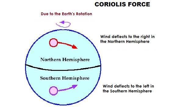
  • Because of the rotation of the Earth, wind deflects to the right in the Northern Hemisphere and left in the Southern Hemisphere. The phenomena first reported by Coriolis and hence it is known as Coriolis Force.

Coriolis Force
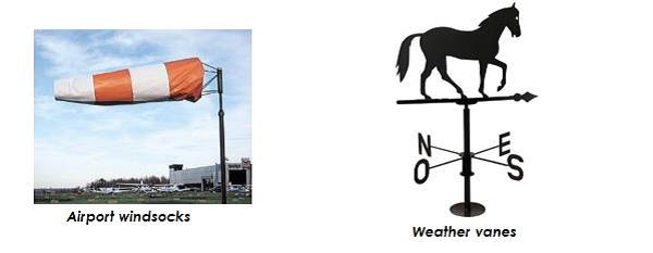
  • To read the wind direction, weather vanes are used; however, at the airport, windsocks are used (indicated the wind direction).

Weather Vanes
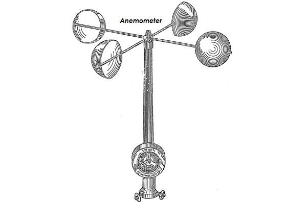
  • Anemometer is used to measure the wind speed.

Anemometer

Types of Winds

  • Winds normally are categorized as −

    • Primary Winds: It is also known as Prevailing Winds and Planetary Winds.

    • Secondary winds: It is also known as Periodic Winds and Seasonal Winds.

    • Local Winds: It is originated because of the local temperature and/or pressure difference.

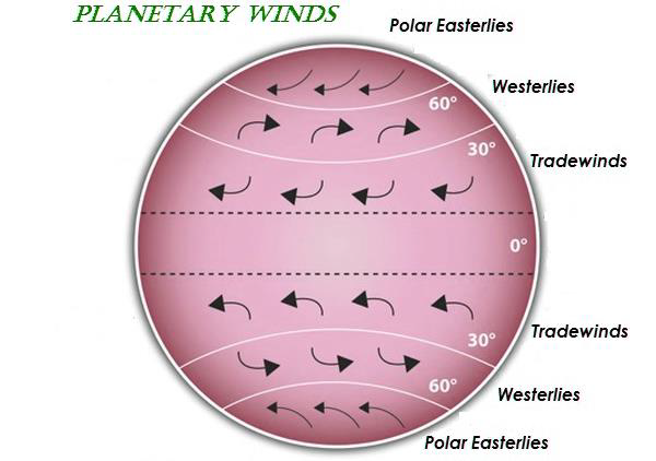
  • Major Planetary Winds (as shown in the following image) are −

    • Polar Easterlies

    • Westerlies (Mid-latitude)

    • Trade Winds (Tropics)

Planetary Winds
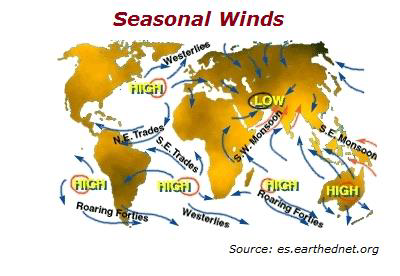
  • Seasonal or Periodic Winds blow periodically i.e. for a specific period. For example, Monsoons (as shown in the following image).

Seasonal Winds
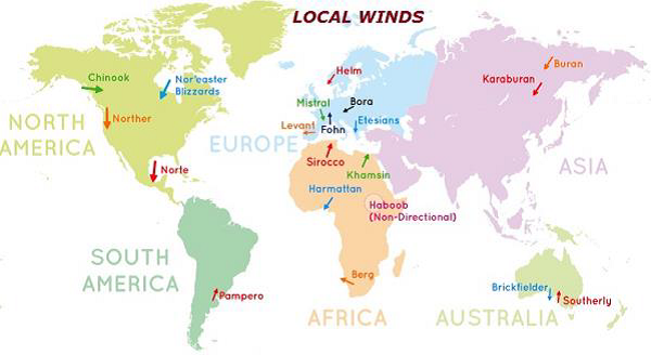
  • Local Winds, which are originated largely because of the temperature differences are a localized phenomenon. The following map shows the major local winds of the world −

Local Winds
Local WindsRegion/Location
ChinookCanada & USA (Rockies Mountain Region)
Santa AnasCalifornia (USA)
PamperoArgentina (South America)
ZondaArgentina (South America)
NorteMexico (Central America)
PapagayoMexico (Central America)
FoehnSwitzerland (Alps Region)
SalanoSouth Spain
MistralFrance
TramontanaNorth Italy
LevantSouth France
HelmEngland
EtesianGreece
BergSouth Africa
SiroccoSahara Region (North Africa)
KhamsinEgypt
GibliTunisia
Harmattan (also known as Doctor Wind)West Africa
BoraSouth & South Eastern Europe
LooNorthern India & Pakistan
SimoonArabia
Buran (also known as Purga)East Asia
KaraburanCentral Asia
BrickfielderVictoria (Australia)
NorwesterNew Zealand

The highlighted terms (blue in color) are shown in the map given above.

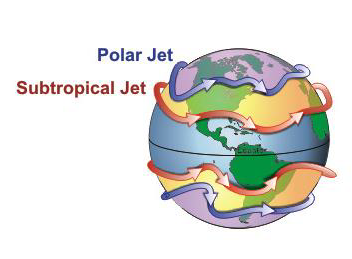
Jet Streams

  • Jet streams are narrow and meandered strip of fast blowing air currents found in the upper altitude (i.e. upper troposphere or lower stratosphere).

Polar Jet

El Niño

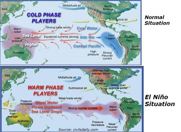
  • El Niño, also known as El Niño Southern Oscillation (or ENSO), refers to the cycle of warm and cold temperatures, as measured by sea surface temperature, of the tropical central and eastern Pacific Ocean. However, the cool phase of ENSO is known as "La Niña."

  • El Niño is accompanied by high air pressure in the western Pacific and low air pressure in the eastern Pacific (as shown in the following image).

Nino Situation

Cyclone

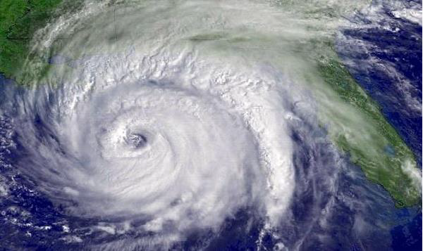
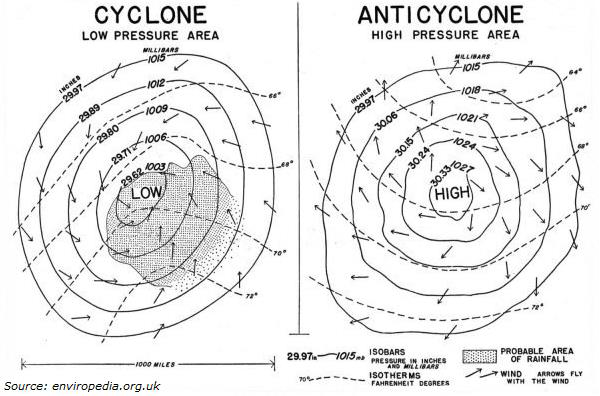
  • Cyclone is a large-scale air mass that keeps rotating around a strong center of low pressure. It rotates counterclockwise in the Northern Hemisphere and clockwise in the Southern Hemisphere.
  • In the northeastern Pacific oceans and the Atlantic Ocean, the tropical cyclone is known as “Hurricane.”

Cyclone

  • In the Indian and south Pacific Oceans, the tropical cyclone is called as “Cyclone,” and in the northwestern Pacific Ocean it is known as “Typhoon.”

  • In the South Indian Ocean (specifically South-west of Australia), a tropical cyclone is known as “Willy-Willy.”

Anticyclone

  • Anticyclone is a large-scale wind system that circulates around a central region of high atmospheric pressure. It rotates clockwise in the Northern Hemisphere and anti-clockwise in the Southern Hemisphere (the following image illustrates the comparative structure of cyclone and anti-cyclone).
Cyclone Anticyclone


Earth's atmosphere

  • The composition of the Earth’s atmosphere changes with the altitude.
  • The major constituents of the Earth’s atmosphere are −

    • Nitrogen – 78.09%

    • Oxygen – 20.95%

    • Argon – 0.93%

    • Carbon Dioxide – 0.039% (remaining other gasses)

  • The pressure exerted by the weight of air at a given point is known as “Atmospheric Pressure” or “Barometric Pressure.”

  • With increasing altitude, the atmospheric pressure decreases.
  • On an average, a column of air (which is normally one square centimeter in cross-section), measured at the sea level, has the weight of about 1.03 kg (about 10.1 N).

  • The Average Air Pressure is about 14.70 pounds per square inch, (equivalent to 1,013.25 × 103 dynes per square centimeter or 1,013.25 millibars) at the sea level.

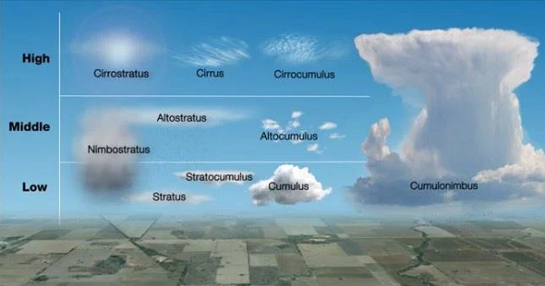
  • A visible mass of condensed vapor floating above the general level of the ground is known as Cloud.

  • Based on the altitude, cloud is classified as −

    • High Altitude Cloud: For example, Cirrus, Cirrocumulus, & Cirrostratus.

    • Middle Altitude Cloud: For example, Altostratus and Altocumulus.

    • Low Altitude Cloud: Stratus, Stratocumulus, Cumulus, and Nimbostratus (it can be also seen in the middle altitude).

    • Vertical: Cumulonimbus

Atmosphere
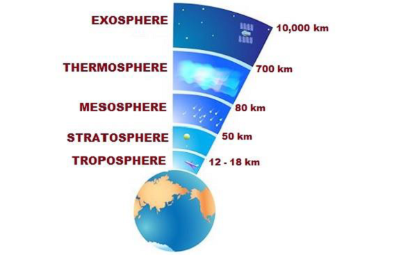
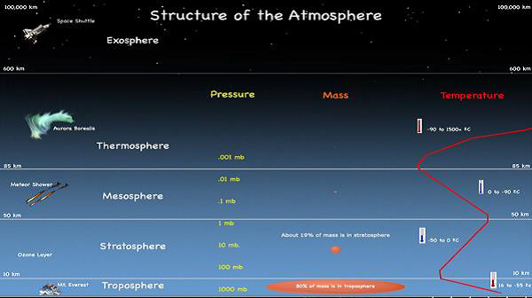
    • The structure of the atmosphere is classified into the following layers −

      • Troposphere: 0 to 12 km

      • Stratosphere: 12 to 50 km

      • Mesosphere: 50 to 80 km

      • Thermosphere: 80 to 700 km

      • Exosphere: 700 to 10,000 km

    Troposphere

    • Troposphere is the closest to the Earth’s surface and contains water vapor (clouds), moisture, dust, etc.

    • Most of the weather phenomena take place in Troposphere.

    Troposphere

    • Height of the Troposphere varies i.e. at the equator, it is measured about 18 km and at the poles, it is 12 km.

    • Tropopause is the transitional zone that separates Troposphere and Stratosphere.

    Stratosphere

    • Stratosphere is the second-lowest layer of the Earth’s Atmosphere that goes up to 50 km.

    • Stratosphere contains Ozone (O3) Layer that absorbs the ultraviolet rays (coming through the Sun rays) and protects life on the Earth.

    • As the ultraviolet radiation absorbs in Stratosphere, therefore the temperature rises with increasing altitude.

    • The Stratopause is the transitional zone that separates Stratosphere and Mesosphere.

    Mesosphere

    • Mesosphere, present above the Stratosphere, extends up to (from 50 km to) 80 km.

    • Temperature in the Mesosphere decreases with increasing altitude.

    • Mesopause is the transitional zone that separates Mesosphere and Thermosphere.

    Thermosphere

    • Above the Mesosphere, Thermosphere is the second-highest layer that starts at the altitude of 80 km and extends up to (roughly) 700 km (however, it varies between 500 and 1000 km).

    • The lower part of the Thermosphere (roughly between 80 km and 550 km) contains ions and known as Ionosphere.

    • The temperature of the Thermosphere rises with increasing altitude.

    • Thermopause is the transitional zone that separates Thermosphere and Exosphere.

    Exosphere

    • Exosphere is the highest or outermost layer of the Earth’s atmosphere that extends (starting from 700 km altitude) up to 10,000 km where it ultimately merges into the solar wind.

    • Major constituents of the Exosphere are helium, hydrogen, nitrogen, oxygen, and carbon dioxide.

    • The phenomena of Aurora Borealis and Aurora Australis can be seen in the lower part of the Exosphere (merged with upper part of the Thermosphere).

    Structure of Atmosphere

    • The Satellite (orbiting the Earth) is normally placed in the Exosphere (as shown in the image given above).

Earth movement

  • The Earth’s rotation on its axis causes day and night.

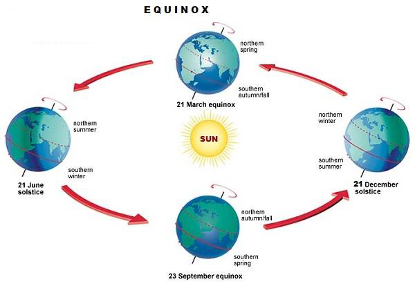
  • The Earth’s revolution (in its orbit around the Sun) causes change in seasons.

  • When nights and days are equal is known as ‘Equinoxes.’ During the equinox’s time, the Sun shines exactly over the equator.

  • March 21 (of every year) is known as the vernal (spring) equinox and September 23 (of every year) is known as the autumnal equinox.

Equinox
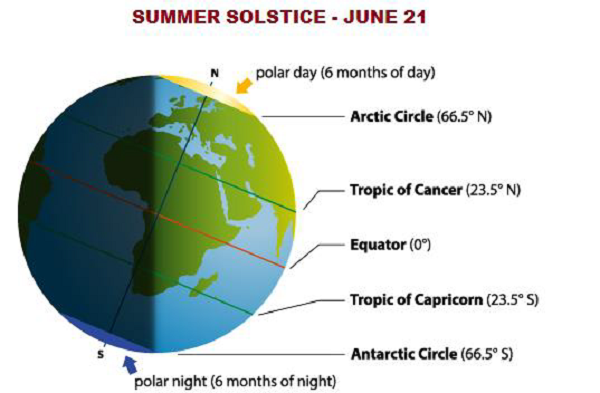
  • When the difference between the length of day and night is maximum is known as ‘Solstice.’

  • During the solstice time, the Sun shines over the tropics (either on Tropic of Cancer or Tropic Capricorn).

  • 23.500 North represents ‘Tropic of Cancer.’ On June 21, the Sun shines over the Tropic of Cancer and it is known as the longest day of the year.

  • June 21 is known as the Summer Solstice.

Summer Solstice
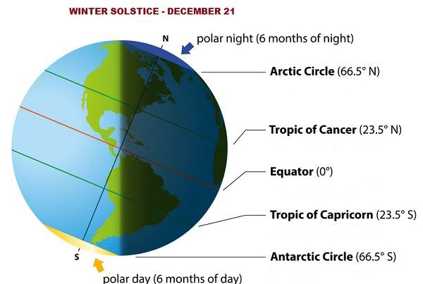
  • 23.500 South represents ‘Tropic of Capricorn.’ On December 21, the Sun shines over the Tropic of Capricorn and it is known as the longest night of the year.

  • December 21 is known as Winter Solstice.

Winter Solstice
  • When light of a celestial body is obscured by another celestial body, the situation is known as ‘Eclipse.’

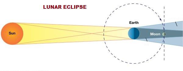
  • When the Earth comes between the Sun and the Moon, it is known as “Lunar Eclipse.”

Lunar Eclipse
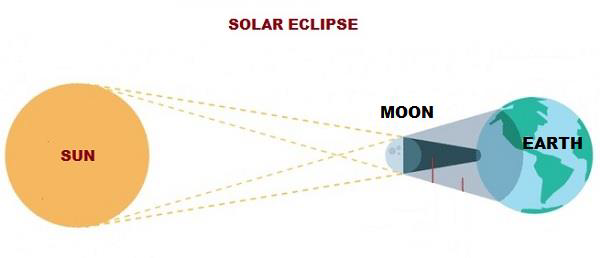
  • When the Moon come between the Sun and the Earth, it is known as “Solar Eclipse.”

Solar Eclipse

Geological time scale

The following table describes Geological Time Scale in brief −

EraPeriodPeriodAge (as Million Years Ago – MYA)Major Events

Cenozoic

It is the Age of Mammals.

(about 65.5 MYA to Present Day)

QuaternaryHolocene0.01 MYA to presentEnd of the Ice Age and dominance of human beings.
Pleistocene1.6 MYAIce Age began and the earliest human appeared.
TertiaryPliocene5.3 MYATrace of human ancestors.
Miocene23.7 MYAAbundance of grass.
Oligocene36.6 MYADominance of mammals.
Eocene57.8 MYAExtinction incident
Paleocene65.5 MYAFirst large mammals evidenced.

Mesozoic

Age of Reptiles.

(about 245 MYA to 65.5 MYA

CretaceousExtinction of Dinosaurs144 MYAFlowering plants appeared.
Jurassic208 MYAFirst birds appeared.
TriassiFirst Dinosaurs245 MYAReptiles were dominant and evidence of first mammals.

Paleozoic

(about 570 MYA to 245 MYA)

PermianAge of Amphibians286 MYA
Carboniferous360 MYAFirst Reptile and large fish appeared.
DevonianAge of Fishes408 MYAFirst land animal appeared.
Silurian438 MYAFirst insects, land plants, & jawed fish appeared.
Ordovician505 MYAExtinction incident evidenced.
Cambrian570 MYAFirst fungi evidenced.

Precambrian

(about 4600 MYA to 570 MYA)

Proterozoic2500 MYAFirst multicellular life appeared.
Achean3800 MYAFirst unicellular life appeared.
HadeanPriscoan4600 MYAEarth cooled and atmosphere and Ocean formed

ನ್ಯೂಕ್ಲಿಯರ್ ಪುಟ್ ಬಾಲ್ ನ ಮಾಹಿತಿ

ಪೆಂಟಗನ್ ಇತ್ತೀಚೆಗೆ ಅಧ್ಯಕ್ಷರ ಪರಮಾಣು ಫುಟ್ಬಾಲ್ ಸುತ್ತಲಿನ ಸುರಕ್ಷತಾ ಪ್ರೋಟೋಕಾಲ್ಗಳನ್ನು ಮೌಲ್ಯಮಾಪನ ಮಾಡುವುದಾಗಿ ಹೇಳಿದೆ.  ಇದು ಸ್ಟ್ರೈಕ್‌ಗೆ ಅಗತ್ಯವಿರುವ ಕೋಡ್‌ಗಳನ್ನು ಒಳಗೊಂಡಿದೆ.  ಜನವರಿ 6, 2021 ರಂದು ಕ್ಯಾಪಿಟಲ್‌ಗೆ ನುಗ್ಗಿದ ದಂಗೆಕೋರರ ವ್ಯಾಪ್ತಿಯಲ್ಲಿ ಒಂದು ಬ್ರೀಫ್‌ಕೇಸ್ ಬಂದ ನಂತರ ಇದು ಸಂಭವಿಸಿತು.

 ನ್ಯೂಕ್ಲಿಯರ್ ಫುಟ್ಬಾಲ್ ಒಂದು ಬ್ರೀಫ್ಕೇಸ್ ಆಗಿದ್ದು ಅದು ಯುನೈಟೆಡ್ ಸ್ಟೇಟ್ಸ್ನ ಅಧ್ಯಕ್ಷರು ಬಳಸಬೇಕಾದ ವಸ್ತುಗಳನ್ನು ಒಳಗೊಂಡಿದೆ, ಇದರಿಂದಾಗಿ ಅವನು/ಅವಳು ಪರಮಾಣು ಕಮಾಂಡ್ ಸೆಂಟರ್ಗಳಿಂದ ದೂರದಲ್ಲಿರುವಾಗ ಯಾವುದೇ ಪರಮಾಣು ದಾಳಿಯನ್ನು ಅಧಿಕೃತಗೊಳಿಸಬಹುದು.

 ಯುನೈಟೆಡ್ ಸ್ಟೇಟ್ಸ್ನ ಅಧ್ಯಕ್ಷರು ಮಿಲಿಟರಿ ನೆರವಿನೊಂದಿಗೆ, ಯಾವಾಗಲೂ ಪರಮಾಣು ಶಸ್ತ್ರಾಸ್ತ್ರಗಳ ಉಡಾವಣಾ ಸಂಕೇತಗಳನ್ನು ಒಳಗೊಂಡಿರುವ ಫುಟ್ಬಾಲ್ ಅನ್ನು ಒಯ್ಯುತ್ತಾರೆ.

 ರಾಷ್ಟ್ರಪತಿಗಳಿಗೆ ಪರಮಾಣು ಅಸ್ತ್ರವನ್ನು ಉಡಾಯಿಸುವ ಸಂಪೂರ್ಣ ಅಧಿಕಾರವಿದೆ.  ಇದಕ್ಕಾಗಿ ಅವರು ಈ ಕೆಳಗಿನ ಹಂತಗಳನ್ನು ಅನುಸರಿಸುತ್ತಾರೆ

 i) ಸಲಹೆಗಾರರೊಂದಿಗೆ ಭೇಟಿ: ಅಧ್ಯಕ್ಷರು ಸಲಹೆಗಾರರನ್ನು ಭೇಟಿಯಾಗುತ್ತಾರೆ ಅಥವಾ ಫೋನ್ ಕರೆ ಮೂಲಕ ನಡೆಸಬಹುದು.  ಕ್ಷೇತ್ರದಲ್ಲಿ ಇರುವವರ ಅಂತಿಮ ಮಾತು ಕೂಡ ಮುಖ್ಯವಾಗಿದೆ.  ಇದಲ್ಲದೆ ಅವರು ಅವನನ್ನು/ಅವಳನ್ನು ನೆಲದ ವಾಸ್ತವತೆಯ ಬಗ್ಗೆ ಅಪ್‌ಡೇಟ್ ಮಾಡುತ್ತಾರೆ

 ii) ಲಾಂಚ್ ಆರ್ಡರ್ ನೀಡಲಾಗಿದೆ: ಇದನ್ನು ಸುರಕ್ಷಿತ ಸ್ಟೇಷನ್ ಅಥವಾ ಪೋರ್ಟಬಲ್ ನ್ಯೂಕ್ಲಿಯರ್ ಫುಟ್ಬಾಲ್ ನೀಡಲಿದೆ.  ಅಧ್ಯಕ್ಷರ ಗುರುತನ್ನು ದೃ isೀಕರಿಸಲಾಗಿದೆ ಮತ್ತು ಉಡಾವಣಾ ಸಂಕೇತಗಳನ್ನು ಪೆಂಟಗನ್‌ನ ಯುದ್ಧ ಕೋಣೆಗೆ ಕಳುಹಿಸಲಾಗುತ್ತದೆ.

 iii) ಆದೇಶ ಹೊರಬಿದ್ದಿದೆ: ಪೆಂಟಗನ್‌ನಲ್ಲಿನ ವಾರ್ ರೂಮ್ ಲಾಂಚ್ ಆರ್ಡರ್‌ಗಳನ್ನು ಎನ್‌ಕ್ರಿಪ್ಟ್ ಮಾಡಿದೆ, ಇದರಲ್ಲಿ ಗುರಿಗಳು, ಉಡಾವಣೆ ಮಾಡಲು ಸಮಯ ಮತ್ತು ಕ್ಷಿಪಣಿಗಳನ್ನು ಅನ್ಲಾಕ್ ಮಾಡಲು ದೃಶ್ಯೀಕರಣ ಕೋಡ್‌ಗಳು ಸೇರಿವೆ.

 iv) ಲಾಂಚ್ ತಯಾರಿ: ಲಾಂಚ್ ಸಿಬ್ಬಂದಿ ದೃ coೀಕರಣ ಸಂಕೇತಗಳನ್ನು ಖಚಿತಪಡಿಸುತ್ತಾರೆ ಮತ್ತು ಕ್ಷಿಪಣಿಗಳನ್ನು ಅನ್ಲಾಕ್ ಮಾಡಲು ಗುರಿ ಮಾಹಿತಿಯನ್ನು ನಮೂದಿಸುತ್ತಾರೆ.  ಆದಾಗ್ಯೂ, ರಕ್ಷಣಾ ಕಾರ್ಯದರ್ಶಿಯ ಭಿನ್ನಾಭಿಪ್ರಾಯದಿಂದ ಅಧ್ಯಕ್ಷರ ಆದೇಶದ ಮೇಲೆ ಪರಿಣಾಮ ಬೀರಬಹುದು ಮತ್ತು ಉಪರಾಷ್ಟ್ರಪತಿ ತಿದ್ದುಪಡಿ 25 ರ ಸೆಕ್ಷನ್ 4 ರ ಅಡಿಯಲ್ಲಿ ರಾಷ್ಟ್ರಪತಿಯು ತನ್ನ ಕರ್ತವ್ಯಗಳನ್ನು ನಿರ್ವಹಿಸಲು ಅಸಮರ್ಥನೆಂದು ಘೋಷಿಸಬಹುದು.  ಅಂತಹ ಸಂದರ್ಭಗಳಲ್ಲಿ ಮಾತ್ರ ಪರಮಾಣು ದಾಳಿಯನ್ನು ನಿಲ್ಲಿಸಬಹುದು.

 v) ಪರಮಾಣು ಅಸ್ತ್ರವನ್ನು ಉಡಾಯಿಸಲಾಗಿದೆ

 ವಾಷಿಂಗ್ಟನ್ ಡಿಸಿ ಯ ಯುನೈಟೆಡ್ ಸ್ಟೇಟ್ಸ್ ಕ್ಯಾಪಿಟಲ್ ನಲ್ಲಿ ಕಾಂಗ್ರೆಸ್ ಅಧ್ಯಕ್ಷರು ಮಾಜಿ ಅಧ್ಯಕ್ಷ ಡೊನಾಲ್ಡ್ ಟ್ರಂಪ್ ಅವರನ್ನು ಬೆಂಬಲಿಸುವ ಗುಂಪೊಂದು ದಾಳಿ ಮಾಡಿತು.  ಚುನಾವಣಾ ಮತಗಳನ್ನು ಎಣಿಸುವ ಮೂಲಕ ಜೋ ಬಿಡೆನ್ ಅವರ ವಿಜಯವನ್ನು ಅನುಮೋದಿಸುವ ಕಾಂಗ್ರೆಸ್ ಜಂಟಿ ಅಧಿವೇಶನವನ್ನು ಅಡ್ಡಿಪಡಿಸುವ ಮೂಲಕ ಅಧ್ಯಕ್ಷೀಯ ಚುನಾವಣೆಯಲ್ಲಿ ಅವರ ಸೋಲನ್ನು ತಿರಸ್ಕರಿಸಲು ಅವರು ಬಯಸಿದರು.

 ಅಧ್ಯಕ್ಷೀಯ ತುರ್ತುಸ್ಥಿತಿ ಸ್ಯಾಚೆಲ್ ಕಳೆದುಹೋದರೆ ಅಥವಾ ರಾಜಿ ಮಾಡಿಕೊಂಡಲ್ಲಿ ಪೆಂಟಗನ್ ಅಧಿಕಾರಿಗಳು ಎಷ್ಟು ಮಟ್ಟಿಗೆ ಪತ್ತೆ ಹಚ್ಚಬಹುದು ಮತ್ತು ಪ್ರತಿಕ್ರಿಯಿಸಬಹುದು ಎಂದು ಪೆಂಟಗನ್ ಹೇಳಿದೆ.  ಆ ದಿನದಂದು ಉಪಾಧ್ಯಕ್ಷ ಮೈಕ್ ಪೆನ್ಸ್ ಬ್ಯಾಕ್ಅಪ್ ನ್ಯೂಕ್ಲಿಯರ್ ಫುಟ್ಬಾಲ್ ಹೊತ್ತ ಮಿಲಿಟರಿ ಸಹಾಯಕರ ಜೊತೆಗಿದ್ದರು, ಪೆಂಟಗನ್ ಅಂತಹ ಪರೀಕ್ಷೆಯನ್ನು ನಡೆಸಲು ಬಯಸುತ್ತದೆ.

what is nuclear football and how is it related to the US President

The Pentagon has recently said that it would be evaluating the safety protocols surrounding the President's nuclear football. This contains the codes that may be needed for a strike. This happened after one of the briefcases nearly came in range of the rioters storming the Capitol on January 6, 2021. 

The nuclear football is a briefcase which contains the things to be used by the President of the United States so that he can authorise any nuclear attack while he/she is away from the nuclear command centers.

The President of the United States is accompanied by military aid, always carrying a football consisting of launch codes for nuclear weapons.

The President has the whole- sole authority to launch the nuclear weapon. For this he follows the following steps

i) Meeting with the advisors: The President meets the advisors or can conduct it over a phone call. The final word of those who are in the field is also important. Moreover they update him/her about the ground reality

ii)Launch order given: It is to be given by a secure station or a portable nuclear football. The president's ID is confirmed and the launch codes are sent to the Pentagon's war room. 

iii) The order is out: The War Room at Pentagon has encrypted launch orders that include targets, time to launch and authentication codes to unlock missiles.

iv) Launch Preparation: Launch crew confirms authentication codes and enters target information to unlock the missiles. However the order of the President can be affected by the Defence Secretary's disagreement and the vice President can pass a motion under Section 4 of Amendment 25 declaring the President incapable of carrying out his/her duties. Only in such cases the nuclear attack can be halted.

v)The nuclear weapon is launched

It was in the United States Capitol in Washington DC that the Congress men were attacked by a mob supporting the ex President Donald Trump. They wished to overturn his defeat in the presidential elections by disrupting the joint session of the Congress approving the victory of Joe Biden by counting of the Electoral votes. 

The Pentagon after that said that it would evaluate the extent to which the Pentagon officials could detect and respond in case the Presidential Emergency Satchel were lost or compromised with. As on that day Vice President Mike Pence was accompanied by the military aide carrying a backup nuclear football, the Pentagon wishes to run such a test. 

The universe and planet (geography)

  • Pythagoras, who was an Ionian Greek philosopher and mathematician, first used the term “COSMOS” for the order of the Universe.

  • Cosmology is the discipline that describes the large scale properties of the universe as a whole.

  • The distance covered by light in one year is known as “Light Year.” The Velocity of light is 300,000 km/s.

  • The distance between the Sun and the Earth is known as “Astronomical Unit.” One astronomical unit is (roughly) equal to 149.6 million kilometers.

  • Wilkinson Microwave Anisotropy Probe (WMAP) is an Explorer Mission of National Aeronautics and Space Administration (NASA). It is launched for the study and measurement of cosmology.

  • Professor Sir Fred Hoyle, who was an English astronomer, coined the term “Big Bang” to explain a scientific theory on the creation of cosmos.

  • Galaxy is a huge collection of stellar and interstellar matter, which are bound together by its own gravity in the Space. There are several galaxies in the universe, for example, Milky Way.

  • The name galaxy where we live is ‘Milky Way.’

  • The largest galaxy is ‘Andromeda Galaxy.’ It is also the closest to Milky Way. Milky Way is the second largest galaxy.

  • The radius of Milky Way is about 50,000 light years.

  • The Solar System is a part of Milky Way.

  • The Sun takes 225 million light years to complete one circuit.

  • The collapsed stars, which are immeasurably dense and having huge gravitational force (even light cannot escape rather get absorbed) are known as “Black Holes.”

  • Quasar is a massive and extremely remote celestial object that keeps emitting remarkably large amounts of energy. Typically, it has a star like image, which can be seen through the telescope.

  • Constellation is a group of stars being arranged in a pictorial configuration. It was basically observed by the ancient astronomers. For example, Sirius (Canis Major), Canopus (Carina), Turus (Bootes), etc.

  • Atacama Large Millimeter Array (ALMA) is the British Astronomy center, located at Chajnantor (at an altitude of about 5,000 meters), in the Atacama Desert of northern Chile.

  • Edwin Hubble, who was an American astronomer, first studied galaxies in detail. Based on Shape, Edwin classified galaxies as Elliptical, Spiral, and Barred Spiral.

  • At the end of life-cycle, when a star loses its light and the density increases (very high), by this time, it is largely composed of neutrons and hence known as ‘Neutron Star.’

  • Most likely, the rotating neutron star emits intermittent radio signals, is known as ‘Pulsar.’

  • A star with low temperature and small mass (glowing feebly) is known as ‘Red Dwarf.’

  • A star that suddenly increases its brightness (greatly) because of a catastrophic explosion and ejects most of its mass is known as ‘Supernova.’

  • Satellites (or Moons) are the bodies that keep revolving around their respective planets. For example, Moon revolves around the Earth, etc.

  • The Sun is the closest star to the Earth (at the distance of about 149,600,000 km).

  • Located at the distance of about 4.24 light-years, Proxima Centauri is the second closest star to the Earth.

  • The Sun is made up of extremely hot gasses and its glowing surface is known as the ‘Photosphere.’ The layer immediately above the photosphere is known as ‘Chromosphere’ (sphere of color).

  • The Chromosphere is 10,000 km thick transparent shell of plasma.

  • The Outermost layer of the Sun is known as the ‘Corona.’

  • Temperature of the outer surface is 6,0000 C and interior temperature is 15,000,0000 C.

  • The rotation period of the Sun is 25 days, 9 hours, and 7 minutes.

  • The traveling speed of the Sun’s Rays is 30,000 m/s.

  • The time taken by Sun’s Rays to reach the Earth is 8 minutes and 16.6 seconds.

  • The Sun is largely composed (chemically) of Hydrogen (71%), Helium (26.5%), and some other elements (2.5%).

  • Sometimes, in the photosphere, some patches of gas, which is cooler that its surrounding (gas) are known as the ‘Sunspots.’

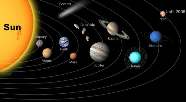
  • The Planets are the celestial bodies that revolve around the Sun as well as (at the same time) rotate on their imaginary axis.

    • There are eight planets namely (arranged in the order of increasing distance from the Sun) −

      • Mercury

      • Venus

      • Earth

      • Mars

      • Jupiter

      • Saturn

      • Uranus

      • Neptune

    • The largest planet is Jupiter and Mercury is the smallest planet of the system.

    Sun

    Mercury

    • Mercury is the nearest to the Sun.

    • Mercury takes 58.65 Earth days to complete its rotation (on its axis) and takes 88 days to complete its one revolution (i.e. in its orbit around the Sun).

    • Mercury is the fastest planet and it has no moon (satellite).

    Venus

    • Venus, which is also popular as an evening star and morning star, is the brightest celestial body in the universe after Sun and Moon.

    • Venus is the Hottest Planet of the solar system. It is closest to the Earth.

    • Venus takes 243 Earth days to complete its rotation (on its axis) and takes 224.7 days to complete its one revolution (i.e. in its orbit around the Sun).

    • Venus has no satellite and it spins in the opposite direction of the Earth’s spin.

    • Venus is named after the Roman goddess of Beauty.

    Earth

    • Earth is the third planet from the Sun.

    • By the time, Earth is the only planet where life exists.

    • Earth takes 23 hours, 56 minutes, and 40 seconds to complete its rotation (on its axis) and takes 365.26 days to complete its one revolution (i.e. in its orbit around the Sun).

    • Mass of the Earth is 5.98 x 1024 kg and its diameter is 12,756 km.

    • Escape Velocity of the Earth is 11,200 m/s.

    • Obliquity (i.e. tilt of axis degrees) of the Earth is 23.40.

    • Mean density of the Earth is 5.514 g/cm3 and the surface is 510,072,000 km2.

    • Mean surface temperature of the Earth is 281 K; the mean maximum surface temperature is 310 K and the mean minimum surface temperature is 260 K.

    • The major atmospheric components of the Earth are Nitrogen (78%), Oxygen (20.95%), Argon (0.930%), and Carbon Dioxide (0.039%).

    Moon

    • Moon is the only known satellite of the Earth.

    • Moons rotation time (on its axis) and revolution time (around the Earth) is same (i.e. 27 days, 7 hours, 43 minutes, and 11.47 seconds. This is the reason that we always see only one side of the Moon.

    • Moon revolves around the Earth once in every 27.3 days, which is known as ‘Sidereal Month;’ however, it takes 29.5 days to return to the same point on the celestial sphere in reference to the Sun (due to revolution motion of the Earth around the Sun) and it is known as ‘Synodic Month.’

    • When two full Moons occur in the same month, it is known as ‘Blue Moon.’

    • Full Moon is basically the lunar phase that occurs when the Moon is completely illuminated as seen from the Earth.

    • As shown in the following image, the Lunar Phase or phase of the moon, is the shape of the illuminated portion of the Moon that is visible from the Earth. As Moon revolves, the lunar phases change cyclically and we can see from the full moon (full visible) to the new moon (not at all visible).

    Moon

    Mars

    • Mars is known as the ‘Red Planet’ of the solar system.

    • Mars takes 24 hours, 37 minutes, and 30 seconds to complete its rotation (on its axis) and takes 687 days to complete its one revolution (i.e. in its orbit around the Sun).

    • Mars has two satellites namely Phobos (means fear) and Deimos (means terror).

    Jupiter

    • Jupiter takes 9 hours, 50 minutes, and 30 seconds to complete its rotation (on its axis) and takes 12 earth years to complete its one revolution (i.e. in its orbit around the Sun).

    • Jupiter has 63 natural satellites/moon, significant of them are Europa, Ganymede, Callisto, etc. Among all, Ganymede is the largest satellite in the whole solar system.

    Saturn

    • Saturn is the largest planet after Jupiter in the solar system.

    • Saturn is popular for its spectacular rings system.

    • The rings system of Saturn is made up of a variety of separate particles that rotate in circular orbits independently.

    • Saturn takes 10 hours and 14 minutes to complete its rotation (on its axis) and takes 30 years to complete its one revolution (i.e. in its orbit around the Sun).

    • Saturn has total 47 satellites/moons; among them, Titan is the biggest satellite.

    Uranus

    • Uranus is first identified as planet by William Herschel in 1781.

    • Like Saturn, Uranus also has a system of five faint rings.

    • Uranus takes 16 hours to complete its rotation (on its axis) and takes 84 years to complete its one revolution (i.e. in its orbit around the Sun).

    • Uranus has 27 satellites; significant of them are Miranda, Ariel, Umbriel, Titania, etc.

    Neptune

    • Neptune is the farthest planet which appears greenish through a telescope.

    • Neptune is discovered by Berlin scientist J. G. Galle in 1846.

    • Neptune takes 18 hours to complete its rotation (on its axis) and takes 165 years to complete its one revolution (i.e. in its orbit around the Sun).

    • Neptune has 13 satellites/moons; significant of them are ‘Triton’ and ‘Nereid.’

    • Until 2006, there were nine planets (including Pluto), but in 2006, the ninth planet Pluto is categorized as the dwarf planet by International Astronomical Union (IAU).

    Asteroids

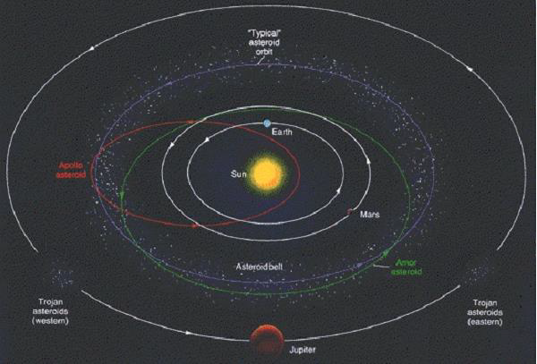
    • Asteroids, also known as small planets or planetoids, are the rocky debris largely found between the planets Mars and Jupiter. These are too small to have their own atmosphere (as shown in the following image).

    Asteroids

    • The Asteroids revolve around the Sun, which varies from 3 to 10 years.

    • By the time, more than 450,000 Asteroids are discovered; the largest Asteroid is Ceres, which diameter is about 1,025 km.

    Meteors

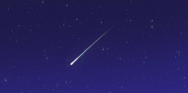
    • Meteors, also popular as ‘Shooting Star’ or ‘Falling Star,’ is the passage of a comet, asteroid, or meteoroid into the Earth's atmosphere. It is heated (because of the collisions with air particles) and normally seen in the upper atmosphere (as shown in the following image).

    Meteors

    • Meteoroids are the small rocky or metallic bodies that normally travel through outer space. Meteoroids are expressively smaller than asteroids, and its size ranges from small grains to 1-meter-wide objects.

    Comets

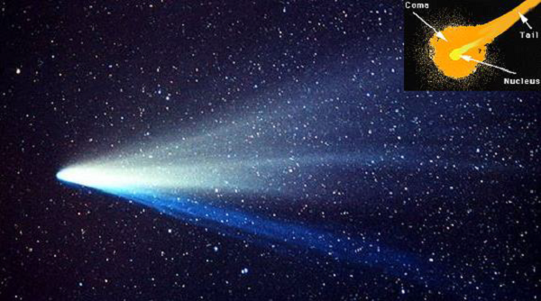
    • Comets are the icy small Solar System body; normally while passing close to the Sun, heats up and starts to outgas, displaying a visible atmosphere (i.e. basically coma) along with a tail (as shown in the following image – in the insat view).

    Comets

    • Total surface area of the Earth is 510,100,500 sq. km, out of which −

      • The total land area is 148,950,800 sq. km (29.08% of total area) and

      • The total water area is 361,149,700 sq. km (70.92%).

    • Diameter of the Earth at Equator is 12,755 km, at the poles 12,712 km, and mean diameter is 12,734 km.

    Diameter of Earth
    • Circumference of the Earth at Equator is 40,075 km and at the poles 40,024 km.

    • Equatorial radius of the Earth is 6,377 km.

    • The total mass of the Earth is 5.98 x 1024 kg.

    • Approximate age of the Earth is 4,500 million years.

    • The mean velocity of the Earth in its orbit (around the Sun) is 107,218 km/h.

    • The most abundant elements of the Earth are

      • Iron (about 32.5%),

      • Oxygen (29.8%),

      • Silicon (15.6%), and

      • Magnesium (13.9%)

    Structure of Earth

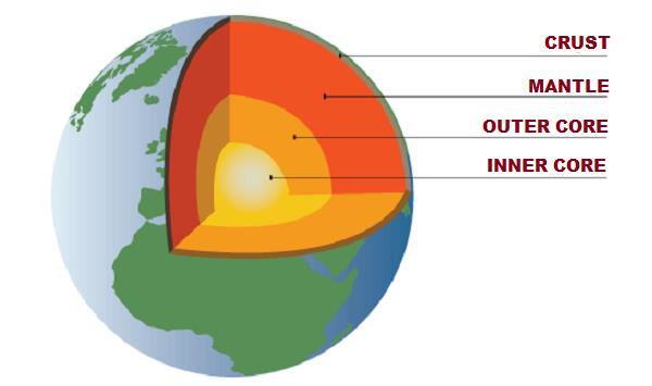
    • The Earth is structured in three layers namely −

      • Crust,

      • Mantle, and

      • Core – Further classified as outer core (fluid layer) and inner core (solid layer).

    Structure of Earth
    • The Crust is the uppermost layer of the Earth, largely composed of rocks. Its thickness ranges from 5 km to 60 km and density ranges from 2.7 to 3.

    • The Crust shares about 1 percent of Earth’s volume.

    • The Crust is categorized as ‘Continental Crust’ and ‘Oceanic Crust.’

    • The thickness of Continental Crust ranges from 30 km to 50 km. It is largely composed by granites, which density (i.e. 2.7) is lesser than the Oceanic Crust.

    • The thickness of Oceanic Crust ranges from 5 km to 10 km and it is composed primarily of basalt, diabase, and gabbro.

    • The density of Oceanic Crust is 3.0.

    • The most abundant element of Crust is Oxygen (46.6%) followed by Silicon (27.7%) and Aluminum (8.1%).

    • The Crust is also known as ‘Sial’ (i.e. Silicon and Aluminum)

    • The boundary between the Crust and the Mantle is known as the “Mohorovičić Discontinuity.”

    • The Mantle is located between the Crust and the (Outer) Core, which thickness is about 2885 km.

    • The Mantle shares about 83% of the Earth’s volume and about 65% of the mass.

    • The density of Mantle is about 3.4 g/cm3.

    • The upper layer of Mantle is known as ‘Asthenosphere.’

    • The Crust and the upper part of Mantle collectively known as ‘Lithosphere.’

    • The Core is mostly composed of iron and nickel; therefore, it is also known as ‘Nife’ (i.e. Nickel and Ferrous).

    • The Core shares about 16% of Earth’s total volume and 30% of the mass.

    • The thickness of the Core is about 3,400 km from the Mantle (likewise, the total depth from the Surface of the Earth is 6,300 km).

    • Core is categorized as outer core (which is in molten state) and inner core (which is in solid state).

    • Density of the inner core is about 13 g/cm3.

The Schedule of the Indian Constitution −

The following table describes the Schedule of the Indian Constitution −

ScheduleContains
First ScheduleLists the states and territories of India (also about their changes)
Second ScheduleLists the salaries of officials holding public office, Presidents, judges, and Comptroller and Auditor General of India
Third ScheduleForms of oaths and Affirmations of offices for elected officials including judges
Fourth ScheduleAllocation of seats in the Rajya Sabha (the Upper House of Parliament) per State or Union Territory
Fifth ScheduleProvisions as to the Administration and Control of Scheduled Areas and Scheduled Tribes
Sixth ScheduleProvisions as to the Administration of Tribal Areas in the States of Assam, Meghalaya, Tripura, and Mizoram
Seventh ScheduleThe Union (central government), state, and concurrent lists of responsibilities
Eight ScheduleThe Languages
Ninth ScheduleValidation of certain Acts and Regulations
Tenth Schedule"Anti-defection" provisions for the Members of Parliament and the Members of the State Legislatures
Eleventh SchedulePanchayat Raj (rural local government)
Twelfth ScheduleMunicipalities (urban local government)

The Parts and Articles of the Indian Constitutions −

The following table enlists the Parts and Articles of the Indian Constitutions −

PartContainsArticles
Part IUnion and its Territory1 to 4
Part IICitizenship5 to 11
Part IIIFundamental Rights12 to 35
Part IVDirective Principles of State Policy36 to 51
Part IVAFundamental Duties51A
Part VThe Union52 to 151
Part VIThe States152 to 237
Part VIIStates in the B part of the First schedule (repealed by 7th Amendment)
Part VIIIThe Union Territories239 to 242
Part IXThe Panchayats243 to 243O
Part IXAThe Municipalities243P to 243ZG
Part IXBThe Co-operative Societies243ZH to 243ZT
Part XThe scheduled and Tribal Areas244 to 244A
Part XIRelations between the Union and the States245 to 263
Part XIIFinance, Property, Contracts and Suits264 to 300A
Part XIIITrade and Commerce within the territory of India301 to 307
Part XIVServices Under the Union, the States308 to 323
Part XIVATribunals323A to 323B
Part XVElections324 to 329A
Part XVISpecial Provisions Relating to certain Classes330 to 342
Part XVIILanguages343 to 351
Part XVIIIEmergency Provisions352 to 360
Part XIXMiscellaneous361 to 367
Part XXAmendment of the Constitution368
Part XXITemporary, Transitional and Special Provisions369 to 392
Part XXIIShort title, date of commencement, etc.393 to 395

The major Revolutionary Organizations of Modern India −

The following table describes the major Revolutionary Organizations of Modern India −

NameFounderPlaceYear
Vyayam MandalaChapekar BrothersPoona1896-97
Mitra Mela (from 1903, it is transformed as Abhinav Bharat Society/Young India Society)Savarkar BrothersNasik1901
Anushilan SamitiSatish Chandra Basu * Pramathanath MitraCalcutta1902
Swadesh Bandhab SamitiAshwini Kumar DuttaN/A1905
Hindustan Republican Association (HRA)Sachindra Nath Sanyal, Narendra Mohan Sen, Pratul GangulyKanpur1924
Bharat Naujawan SabhaBhagat SinghLahore1926
Hindustan Socialist Republican Association Army (HSRA)Chandrasekhar Azad, Bhagat Singh, Sukhdev ThaparNew Delhi1928
Indian Home Rule SocietyShyamji Krishna VarmaLondon1905
Indian Independence LeagueTaraknath DasCalifornia (USA)1907
Gadar PartyLala HardayalUSA & Canada1913

The major Lower Caste Movements of Modern India −

The following table describes the major Lower Caste Movements of Modern India −

NameFounderPlaceYear
Satyashodhak SamajJyotirao PhuleMaharashtra1873
Aruvippuram MovementSri Narayana GuruAruvippuram, Kerala1888
The Depressed Class Mission SocietyMahrshi Vitthal Ramji ShindeBombay1906
Justice Party (officially the South Indian Liberal Federation)T. M. Nair and P. Theagaraya ChettyMadras, Tamil Nadu1916
Bahishkrit Hitakarini SabhaB. R. AmbedkarBombay1924
Self-Respect MovementE. V. Ramasamy (also called as Periyar by his devoted followers)Madras, Tamil Nadu1925
Harijan Sevak SanghMahatma GandhiPune1932

The major Socio-Religious Movements of Modern India −

The following table describes the major Socio-Religious Movements of Modern India −

NameFounderPlaceYear
Atmiya SabhaRammohan RoyCalcutta1815
Brahmo SamajRammohan RoyCalcutta1828
Dharma SabhaRadhakant DevCalcutta1829
Tattvabodhini SabhaDebendranath TagoreCalcutta1839
Manav Dharma SabhaMehtaji Durgaram ManchharamSurat1844
Paramhansa MandliDadoba PandurangBombay1849
Radha Swami SatsangTulsi RamAgra1861
Brahmo Samaj of IndiaKeshub Chunder SenCalcutta1866
Dar-ul-UlumMuhammad Qasim Nanotvi,Rasheed Ahmed Gangohi and 'Abid HusaiynDeoband (a town in Saharanpur, UP)1866
Prarthna SamajDr. Atmaram PandurangBombay1867
Arya SamajSwami DayanandaBombay1875
Theosophical SocietyHelena Petrovna Blavatsky, Colonel Henry Steel Olcott, William Quan JudgeNew York City, United States1875
Sadharan Brahmo SamajAnanda Mohan Bose, Sib Chandra Deb and Umesh Chandra DuttaCalcutta1878
Deccan Education SocietyVishnushastri Chiplunkar, Bal Gangadhar Tilak, Gopal Ganesh AgarkarPune1884
Muhammadan Educational ConferenceSir Syed Ahmad KhanAligarh1886
Deva SamajShiv Narayan AgnihotriLahore1887
Ramakrishna MissionSwami VivekanandBelur1897
Servants of IndiaGopal Krishna GokhalePune1905
Seva Sadan SocietyRamabai RanadePune1909
Social Service LeagueNarayan Malhar JoshiBombay1911

The major monuments of India −

The following table enlists the major monuments of India −

MonumentsConstructed byLocation
Nalanda UniversityGupta DynastyRajgir, Nalanda (Bihar)
The seven Pagodas of MahabalipuramNarasimhavarman IIMahabalipuram (Tamil Nadu)
Jagannatha TempleKing Anantavarman Chodaganga Deva (Eastern Ganga Dynasty)Puri, Odisha
Lingaraj TempleSomavamsi DynastyBhubaneswar, Odhisha
Khajuraho Group of MonumentsChandela DynastyChhatarpur, Madhya Pradesh
Brihadeeswara Temple (also known as RajaRajeswara Temple)Raja Raja Chola IThanjavur, Tamil Nadu
Ajanta CavesSatavahana Dynasty later Mauryan DynastyAurangabad, Maharashtra
Ellora CavesKalachuri, Chalukya, and Rashtrakuta DynastiesAurangabad, Maharashtra
Agra FortMughal Emperor AkbarAgra, Uttar Pradesh
Thousand Pillars Temple (also known as Rudreshwara Swamy Temple)Kakatiya DynastyHanamakonda, Telangana
Red FortMughal Emperor Shah JahanDelhi
Taj MahalMughal Emperor Shah JahanAgra, Uttar Pradesh
Konark Sun TempleNarasimhadeva I (Eastern Ganga Dynasty)Konark, Odisha
Fatehpur SikriMughal Emperor AkbarAgra, UP
Bibi Ka MaqbaraMughal Emperor AurangzebAurangabad, Maharashtra
Jama MasjidMughal Emperor Shah JahanDelhi
Mehrangarh FortRao JodhaJodhpur, Rajasthan
TajmahalMughal Emperor Shah JahanAgra, Uttar Pradesh
Qutub MinarQutubuddin AibakDelhi
Makkah MasjidMuhammad Quli Qutb ShahHyderabad, Telangana
Hawa MahalMaharaja Sawai Pratap SinghJaipur, Rajasthan
Moti MasjidMughal Emperor Shah JahanAgra, Uttar Pradesh
Humayun's TombAkbar and Humayun’s wife Empress Bega BegumDelhi
CharminarQuli Qutub ShahHyderabad, Telangana
Elephanta CavesNot exactly knownMumbai (Harbour), Maharashtra
Bara ImambaraAsaf-ud-Daula (Nawab of Awadh)Lucknow, Uttar Pradesh
Dilwara TemplesVastupal-TejpalMount Abu, Rajasthan
Gateway of IndiaBritish Government (Designed by George Wittet)Mumbai City, Maharashtra
India GateDesigned by Edwin LutyensDelhi
Jantar MantarMaharaja Jai SinghDelhi
Parana Qila (Old Fort)Shershah SuriDelhi
Golden TempleFourth Sikh guru, Guru Ram DasAmritsar, Punjab
Victoria MemorialBritish GovernmentKolkata, West Bengal
Thillai Natarajah TempleMade collectively by Pallava, Chola, Pandya, etc.Chidambaram, Tamil Nadu
Group of Hampi MonumentsVijayanagara EmpireHampi, Karnataka
Lotus TempleArchitect - Fariborz SahbaDelhi

The Mughal period authors and their works −

The following table enlists the Mughal period authors and their works −

AuthorWorks
Gulbadan BegamHumayun Nama
Abul FazlAin-i-Akbari
Akbar Nama
Mulla DaudTawarikh-i-Alfi
JahangirTuzuk-i-Jahangiri
Abdul Hamid LahoriPadshah Namah
Inayat KhanShah Jahan Namah
Dara ShikohSafinat-ul Auliya
Sakinat-ul Auliya
Majma-ul-Bahrain
AurangzebRaqqat-e-Alamgiri
BhimsenNuskha-i-Dilkusha
Iswar DasFutuhat-i-Alamgiri
BaburTuzuk-i-Baburi
Amir KhusrauTarikh-i-Alai

major country revolutions of the world −

The following table describes major revolutions of the world −

S.NoName and Explanation
1

The Glorious Revolution or Revolution of 1688

This revolution ended the reign of James II in England and established the reign of William III and Mary II. It also ensured the Parliamentary supremacy over the (British) monarchy.

2

The American Revolution (1765 to 1783)

It was American Independence War against the British Rule.

3

The French Revolution (1790s)

It was the modern revolution in France that had taken place (roughly) between 1789 and 1799.

4

The Haitian Revolution (1791 to 1804)

The revolution was an anti-slavery and anti-colonial insurgence that took place at Saint Domingue (the former French colony).

5

The Russian Revolution (1917) (Also known as the Great October Socialist Revolution)

It was revolution that dismantled the Tsarist autocracy and founded the Soviet Union (in 1917).

6

The Cuban Revolution (1953-59)

It was an armed revolt under the leadership of Fidel Castro against the Cuban President Fulgencio Batista (basically, the US backed authoritarian government).

7

The Hungarian Revolution (of 1956)

It was basically Hungarian Uprising (nationwide) against the government of the Hungarian People's Republic and the Soviet-imposed policies.

8

Iranian Revolution of 1978–79, (also known as Islamic Revolution)

The revolution removed the monarchy system and founded the Islamic republic.

9

China's Cultural Revolution (1966)

The revolution enforced the communism in the country by removing the capitalist, traditional, and cultural elements.

the major Revolutionary Organizations of Modern India :

The following table describes the major Revolutionary Organizations of Modern India −

NameFounderPlaceYear
Vyayam MandalaChapekar BrothersPoona1896-97
Mitra Mela (from 1903, it is transformed as Abhinav Bharat Society/Young India Society)Savarkar BrothersNasik1901
Anushilan SamitiSatish Chandra Basu * Pramathanath MitraCalcutta1902
Swadesh Bandhab SamitiAshwini Kumar DuttaN/A1905
Hindustan Republican Association (HRA)Sachindra Nath Sanyal, Narendra Mohan Sen, Pratul GangulyKanpur1924
Bharat Naujawan SabhaBhagat SinghLahore1926
Hindustan Socialist Republican Association Army (HSRA)Chandrasekhar Azad, Bhagat Singh, Sukhdev ThaparNew Delhi1928
Indian Home Rule SocietyShyamji Krishna VarmaLondon1905
Indian Independence LeagueTaraknath DasCalifornia (USA)1907
Gadar PartyLala HardayalUSA & Canada1913

ಶನಿವಾರ, ಜುಲೈ 31, 2021

Prime Minister Narendra Modi began his address:- 14 engineering colleges in 8 states will start engineering studies in 5 Indian languages- Hindi-Tamil, Telugu, Marathi and Bangla.

Prime Minister Narendra Modi began his address to the educational community on July 29, 2021 by congratulating all  students on the completion of one year of the new National Education Policy.

The Prime Minister recalled that "in the last one year, all you great personalities, teachers, principals, policy makers of the country have worked very hard in bringing the National Education Policy to the ground."

On the occasion, the Prime Minister launched multiple key initiatives including Academic Bank of Credits, SAFAL, National Digital Education Architecture and National Education Technology Forum (NETF) in the field of education. 

Prime Minister Narendra Modi launches multiple key initiatives including Academic Bank of Credits and National Digital Education Architecture, in the field of education pic.twitter.com/KjtGZibjI1

•During his address, the Prime Minister emphasised that we have to think about the future and said that how far we will go in the future, how much we will achieve  will depend on what kind of education we are giving to our youth today. 

•PM Modi highlighted that the 21st century youth wants to make their own systems, their own world. He highlighted how the youth of the country is breaking through shackles in different ways. He noted that the Indian athletes are doing well at the Tokyo Olympics 2020. 

•He emphasised that they are accelerating Digital India. He said, from robotics to sci-fi, Artificial Intelligence to machine learning, many new milestones are being met. 

•The Prime Minister further said that the youth now need freedom from old shackles and cages and the new 'National Education Policy' assures the youth that the country is now completely with them, with their spirits.

•The Prime Minister stated that the Artificial Intelligence program has just been launched to make the youth future oriented, opening the way for an AI driven economy. 

•The Prime Minister highlighted how we have seen this environment for decades when it was believed that to study well one had to go abroad but now for good studies students from abroad come to India. best institutions come to India. 

•14 engineering colleges in 8 states will start engineering studies in 5 Indian languages- Hindi-Tamil, Telugu, Marathi and Bangla.

•A tool has also been developed for translation of engineering course in 11 Indian languages. The move aims to bridge the educational divide and enable children belonging to even poor and vulnerable families gain access to quality education. 

•Indian Sign Language has also been given the status of a language subject for the first time. Now students will be able to read it as a language also.

Indian Sign language has been designated as a subject now. Students can opt to study this. It will promote Indian sign language and will help differently-abled people: PM Modi

•The decision is expected to give a huge boost to Indian Sign Language and help differently abled people in the country. 

•The Prime Minister noted that two new initiatives -National Digital Education Architecture (NDEAR) and National Education Technology Forum (NETF) will work to make digital and economic framework across the country.

•The Prime Minister reiterated bringing about an e-learning transformation and SAFAL portal is expected to work in that direction. 

•PM Modi also spoke about implementation of a universal play school programme in coming times across the country through Vidya Pravesh initiative. He said that the initiative will help bridge the divide between rural and urban and play schools will no longer be limited to urban cities. 

Academic Bank of Credit: The Prime Minister launch the Academic Bank of Credit, which aims to provide multiple entry and exit options for students in Higher education and also the first year Engineering Programmes in Regional Languages and Guidelines for Internationalization of Higher Education.

Vidya Pravesh: The initiative is a three-month play-based school preparation module for Grade 1 students

Indian Sign Language: The Indian Sign Language has been launched as a subject at the secondary level.

NISHTHA 2.0: This is an integrated programme of teacher training designed by NCERT.  

SAFAL (Structured Assessment For Analyzing Learning Levels): SAFAL is a competency-based assessment framework, which has been launched for Grades 3, 5 and 8 in CBSE schools. 

Artificial Intelligence Website: A website dedicated to Artificial Intelligence has also been launched. 

National Digital Education Architecture (NDEAR)

National Education Technology Forum (NETF)

All the new initiatives will mark a significant step towards realization of goals under National Education Policy 2020 and make the education sector more vibrant and accessible.

•The National Education Policy 2020 aims to be the guiding philosophy for changing the learning landscape of the country by making education more holistic and building strong foundations for an Atmanirbhar Bharat.

•It is the first education policy of the 21st century and replaces 34-year-old National Policy on Education (NPE), 1986. 

•The new education policy has been built on five major foundational pillars including- Access, Quality, Equity, Affordability and Accountability.

•The policy has been designed keeping in mind the 2030 Agenda for Sustainable Development and aims to transform India into a vibrant global knowledge superpower by making both school and college education more holistic, flexible and multidisciplinary, to bring out the unique capabilities of each student.